UXO Mapping
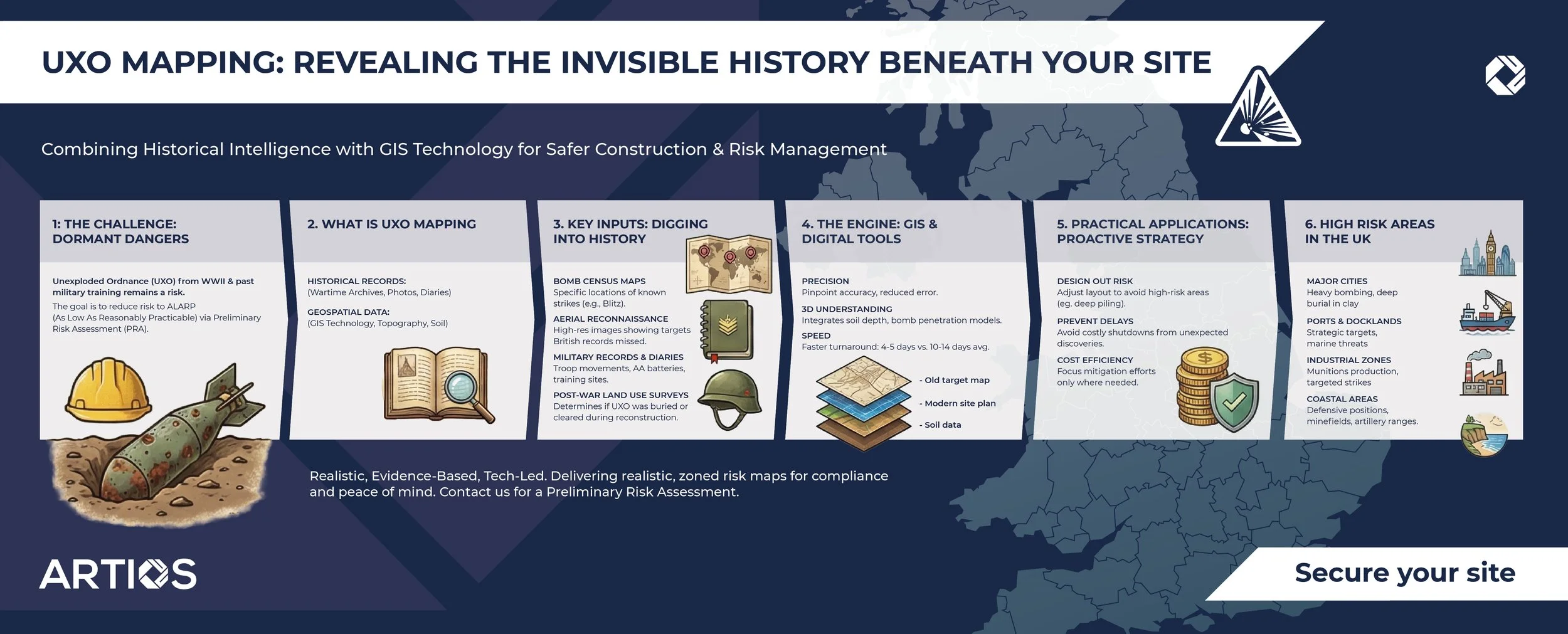
How Historical Data Helps Keep Projects Safe
From the intense aerial bombardment of the Second World War to historic military training exercises in the UK, unexploded ordnance (UXO) remains a significant risk for construction projects in many parts of the UK. Identifying these hazards before breaking ground is a critical component of project planning and risk management.
The first stages (Stage 1& 2), in identifying the risk level that unexploded ordnance poses on a particular site, are the Preliminary Risk Assessment / Detailed Risk Assessment. A key component of this process is the analysis of historical data together with mapping/imagery interpretation to determine whether further measures are required to ultimately ensure that the potential UXO hazard is as low as reasonably practicable (ALARP).
What is UXO Risk Mapping?
UXO mapping is the process of assessing the potential for explosive hazards on a specific site by analysing historical records alongside historical/modern imagery of the site. By comparing historic images and maps with current site topography, assessors can gauge the likelihood of encountering ordnance based on the observed level of post-war land use on site, particularly the level to which the ground has been disturbed/excavated.
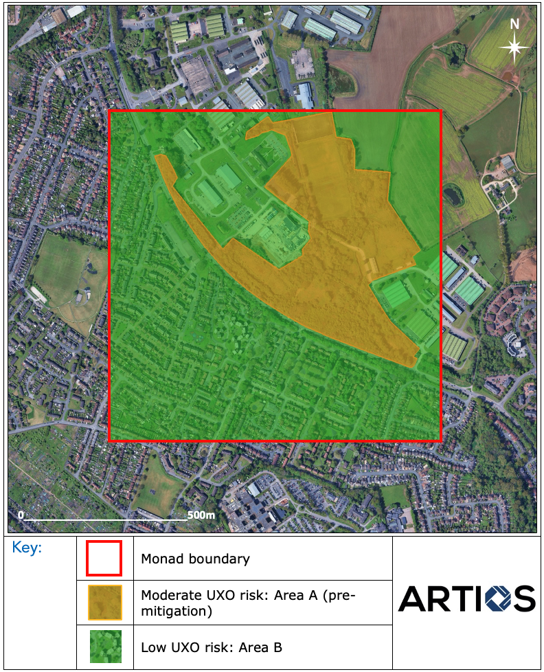
Zoned Risk Map
This blend of rigorous historical research and cutting edge Geographic Information Systems (GIS) technology not only helps identify risks, but also enables certain areas within a site to be ‘ruled out’ from needing risk mitigation and allows for efficient risk management.
UXO mapping is integral to the desktop survey phase and provides a spatial representation of risk that allows stakeholders to make informed decisions. High quality mapping enables risk "zoning," a process that avoids treating an entire site as a uniform hazard. This method allows different areas within a project boundary to be assessed individually based on historical evidence.
For instance, a portion of a site may have been heavily developed with multi-storey structures constructed, the associated excavations for which would likely have already dealt with any UXO that may have been found. On the other hand, UXO may still remain undiscovered in parts of the site that have remained undisturbed since WWII.
By identifying these zones early, developers can focus mitigation efforts precisely where they are needed, optimising safety and compliance while avoiding unnecessary expenditure.
On larger sites, the use of specific areas for military activity, e.g. firing of munitions in coastal areas, also play key role in the ‘zoning’ of sites as part of the UXO mapping.
The Importance of Historical Data
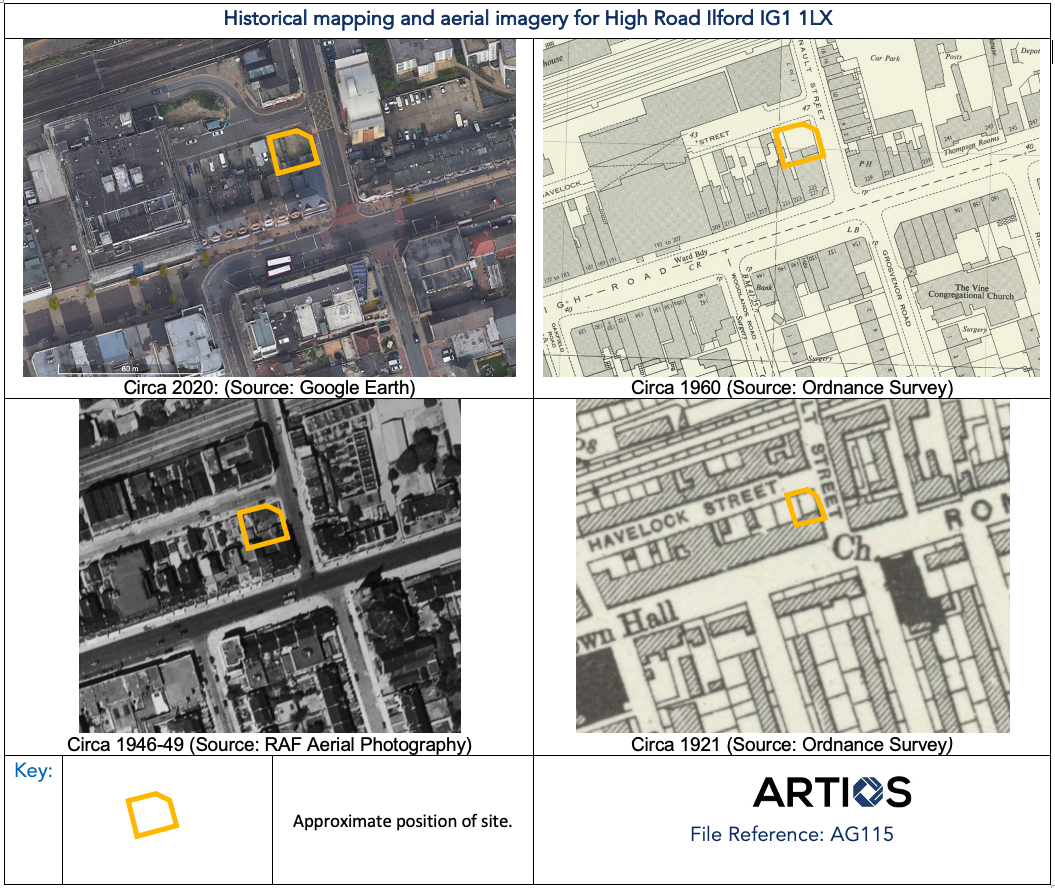
The accuracy of any UXO map relies entirely on the quality and depth of the historical data underpinning it. To build a comprehensive picture of a site’s risk profile, researchers must delve into a vast array of archival sources.
Key sources of historical data include:
Historical OS Maps: Allows for assessment of the layout of the site and development levels on site in the decades after WWII. Labels on old maps are very useful in identifying specific buildings/features and comparing them on modern maps/images.
Aerial Reconnaissance Photography: High resolution images, including those taken by the German Luftwaffe for target maps, provide a glimpse of the development levels on site during and after WWII.
Wartime Bomb Census Maps: These records provide specific locations of known bomb strikes during the Blitz and other air raids.
Military Operational Records and War Diaries: These documents offer insights into troop movements, training exercises and defensive positions (such as anti-aircraft batteries) that may have left behind ordnance.
Post-War Land Use Surveys: Understanding how land was developed or cleared immediately after the conflict helps determine if UXO might have been buried or moved during previous construction.
Artios Global specialises in delivering expert support for Stages 1 to 4, providing realistic, evidence-based assessments to guide your project safely. This historical detail is key to understanding present day risks because generic bombing density maps, often found for free online are insufficient. They typically lack the granularity required for safe construction planning. A site might appear "low risk" on a regional map, but a review of specific regimental diaries or high resolution aerial photography could reveal forgotten details that change the risk profile drastically.
GIS and Digital Tools in UXO Risk Mapping
Historic Imagery/Mapping Analysis
While historical data provides the "what" and "where," Geographic Information Systems (GIS) provide the "how." GIS technology allows analysts to digitise historical data and overlay it onto modern site plans with pinpoint accuracy.
GIS software visualises risk zones and bomb density by layering multiple datasets. For instance, a GIS specialist can overlay a 1940s Luftwaffe target map onto a 2024 topographical survey of a proposed housing development. This allows the team to see exactly what development has occurred on site after WWII (or from whenever UXO contamination may have occurred).
By visualising this data clearly, Artios enables clients to see "heat maps" of risk. A map might show a site washed in green (low risk) with a specific red zone (high risk) around a point of historical/wartime significance . This clarity is essential for communicating risk to non-technical stakeholders and ensuring that mitigation plans are proportionate.
Practical Applications of UXO Mapping
For developers, geotechnical engineers and project managers, accurate UXO mapping is a vital planning tool. It moves UXO risk management from a reactive posture, dealing with a bomb when it is found, to a proactive strategy.
By understanding the specific location of hazards through mapping, engineers can often "design out" the risk. If a high risk zone is identified in a non-critical area of the site (such as a proposed car park or green space), the construction layout can sometimes be adjusted to avoid deep piling or excavation in that specific sector.
Furthermore, accurate mapping prevents costly project delays. If a site is incorrectly assessed as low risk due to poor mapping and a device is discovered during groundworks, the site must be shut down, the police and bomb disposal units called and a cordon established. This can halt a project for days or weeks.
How Artios Supports Safer Development
At Artios Global, we combine impartial, evidence based research with industry leading technology to deliver rigorous UXO risk management. Our approach to UXO mapping ensures that you receive a realistic assessment of risk, not an automated report that recommends unnecessary services.
We leverage advanced GIS tools and deep archival research to provide accurate, zoned risk maps that allow you to manage your project safely and efficiently. Whether you require a Preliminary Risk Assessment to rule out risk or a comprehensive mitigation strategy for a complex site, our expertise ensures compliance with CIRIA C681 and peace of mind for your team.